Recreational uses including bushwalking and mountain bike riding


Sold
Location
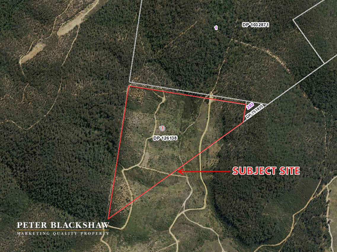
Lot 1/Parish of Urayarra Lot 1 Near Two Sticks Road
Uriarra NSW 2611
Details
Lifestyle
$110,000
Land area: | 28.94 hectares (approx) |
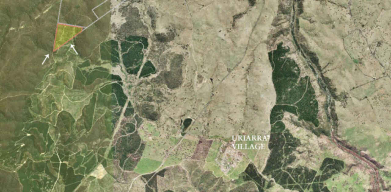
71.5 acre (28.94 hectare) - Triangular shaped block located on the NSW/ACT border, approximately 22km west of Canberra City.
Bounded by Brindabella National Park to the north and pine plantation to the south. Historically used for forestry, the site forms part of Uriarra Forest. In 2003 the pine plantation burnt down with the site now mainly comprising regenerating native vegetation.
The Block offers opportunities for a range of recreational uses including bushwalking and mountain bike riding.
NOTE: The property does not have legal access from a public road. Tracks (either Two Sticks Road or Mountain Creek Road) through the adjoining ACT reserve are subject to closure at the discretion of the ACT Government. These tracks cannot be relied upon to access this property. Sale would be conditional upon the ability of a purchaser to arrange and provide evidence of agreements to practical vehicular access through adjoining private landholdings.
Historic ACT border markers are located on this property and Heritage Management Plans have been prepared to assist the future owner for ease of management.
Located: Latitude: -35.265656 Longitude: 148.877622
Zoned: RU 1 Primary Production
No Dwelling/Building Entitlement
Read MoreBounded by Brindabella National Park to the north and pine plantation to the south. Historically used for forestry, the site forms part of Uriarra Forest. In 2003 the pine plantation burnt down with the site now mainly comprising regenerating native vegetation.
The Block offers opportunities for a range of recreational uses including bushwalking and mountain bike riding.
NOTE: The property does not have legal access from a public road. Tracks (either Two Sticks Road or Mountain Creek Road) through the adjoining ACT reserve are subject to closure at the discretion of the ACT Government. These tracks cannot be relied upon to access this property. Sale would be conditional upon the ability of a purchaser to arrange and provide evidence of agreements to practical vehicular access through adjoining private landholdings.
Historic ACT border markers are located on this property and Heritage Management Plans have been prepared to assist the future owner for ease of management.
Located: Latitude: -35.265656 Longitude: 148.877622
Zoned: RU 1 Primary Production
No Dwelling/Building Entitlement
Inspect
Contact agent
Listing agent
Prior to enquiry or inspection of this property you may wish to review our Information Collection Notice and Privacy Policy.
Privacy & Collection Notice71.5 acre (28.94 hectare) - Triangular shaped block located on the NSW/ACT border, approximately 22km west of Canberra City.
Bounded by Brindabella National Park to the north and pine plantation to the south. Historically used for forestry, the site forms part of Uriarra Forest. In 2003 the pine plantation burnt down with the site now mainly comprising regenerating native vegetation.
The Block offers opportunities for a range of recreational uses including bushwalking and mountain bike riding.
NOTE: The property does not have legal access from a public road. Tracks (either Two Sticks Road or Mountain Creek Road) through the adjoining ACT reserve are subject to closure at the discretion of the ACT Government. These tracks cannot be relied upon to access this property. Sale would be conditional upon the ability of a purchaser to arrange and provide evidence of agreements to practical vehicular access through adjoining private landholdings.
Historic ACT border markers are located on this property and Heritage Management Plans have been prepared to assist the future owner for ease of management.
Located: Latitude: -35.265656 Longitude: 148.877622
Zoned: RU 1 Primary Production
No Dwelling/Building Entitlement
Read MoreBounded by Brindabella National Park to the north and pine plantation to the south. Historically used for forestry, the site forms part of Uriarra Forest. In 2003 the pine plantation burnt down with the site now mainly comprising regenerating native vegetation.
The Block offers opportunities for a range of recreational uses including bushwalking and mountain bike riding.
NOTE: The property does not have legal access from a public road. Tracks (either Two Sticks Road or Mountain Creek Road) through the adjoining ACT reserve are subject to closure at the discretion of the ACT Government. These tracks cannot be relied upon to access this property. Sale would be conditional upon the ability of a purchaser to arrange and provide evidence of agreements to practical vehicular access through adjoining private landholdings.
Historic ACT border markers are located on this property and Heritage Management Plans have been prepared to assist the future owner for ease of management.
Located: Latitude: -35.265656 Longitude: 148.877622
Zoned: RU 1 Primary Production
No Dwelling/Building Entitlement

Location
Lot 1/Parish of Urayarra Lot 1 Near Two Sticks Road
Uriarra NSW 2611
Details
Lifestyle
$110,000
Land area: | 28.94 hectares (approx) |
71.5 acre (28.94 hectare) - Triangular shaped block located on the NSW/ACT border, approximately 22km west of Canberra City.
Bounded by Brindabella National Park to the north and pine plantation to the south. Historically used for forestry, the site forms part of Uriarra Forest. In 2003 the pine plantation burnt down with the site now mainly comprising regenerating native vegetation.
The Block offers opportunities for a range of recreational uses including bushwalking and mountain bike riding.
NOTE: The property does not have legal access from a public road. Tracks (either Two Sticks Road or Mountain Creek Road) through the adjoining ACT reserve are subject to closure at the discretion of the ACT Government. These tracks cannot be relied upon to access this property. Sale would be conditional upon the ability of a purchaser to arrange and provide evidence of agreements to practical vehicular access through adjoining private landholdings.
Historic ACT border markers are located on this property and Heritage Management Plans have been prepared to assist the future owner for ease of management.
Located: Latitude: -35.265656 Longitude: 148.877622
Zoned: RU 1 Primary Production
No Dwelling/Building Entitlement
Read MoreBounded by Brindabella National Park to the north and pine plantation to the south. Historically used for forestry, the site forms part of Uriarra Forest. In 2003 the pine plantation burnt down with the site now mainly comprising regenerating native vegetation.
The Block offers opportunities for a range of recreational uses including bushwalking and mountain bike riding.
NOTE: The property does not have legal access from a public road. Tracks (either Two Sticks Road or Mountain Creek Road) through the adjoining ACT reserve are subject to closure at the discretion of the ACT Government. These tracks cannot be relied upon to access this property. Sale would be conditional upon the ability of a purchaser to arrange and provide evidence of agreements to practical vehicular access through adjoining private landholdings.
Historic ACT border markers are located on this property and Heritage Management Plans have been prepared to assist the future owner for ease of management.
Located: Latitude: -35.265656 Longitude: 148.877622
Zoned: RU 1 Primary Production
No Dwelling/Building Entitlement
Inspect
Contact agent
Listing agent
Prior to enquiry or inspection of this property you may wish to review our Information Collection Notice and Privacy Policy.
Privacy & Collection Notice